Research / University of Twente
Research.
From sensing to autonomy.
The PhD is lightweight perception for aerial robots: one camera, one network predicting depth, semantics, surface normals and edges together, and those predictions driving mapping and autonomous exploration on the drone's own compute, in real time.
From sensing to spatial understanding
- 01
- 02
- 03
- 04
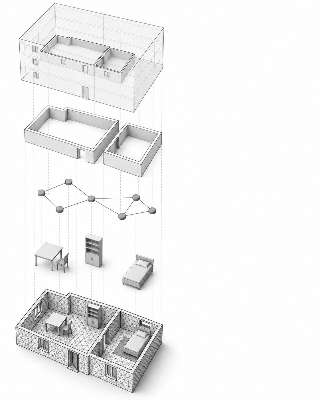
Read the map at five levels
Turn geometry into a map a robot can reason about.
A scene graph connects geometric detail to objects and larger spaces. The illustration shows the hierarchy; the experimental reconstructions appear below.
- BuildingThe top-level environment.
- RoomsRegions that organise the building.
- PlacesConnected locations through the space.
- ObjectsSemantic entities in the map.
- MeshReconstructed geometry carrying semantic labels.
Conceptual thesis illustration, not an experimental reconstruction.
Follow the mapping pipeline ↗Prologue. The same question, ten years earlier
The same question was asked at Peradeniya in 2017: an autonomous exploration planning strategy for a robot mapping an unknown space, using a laser range finder fused with stereo cameras. It is being asked again 10 years later with a learned model and a single camera.
2017 · Peradeniya
Autonomous exploration planning for a reconnaissance agent
An autonomous exploration planning strategy for a reconnaissance robot mapping an unknown space, with a laser range finder fused with stereo cameras. I was the SLAM developer, one of three students on the project.
2026 · ITC, University of Twente
Monocular 3D scene graphs, built in real time
The same job with the scanner removed. One camera and an IMU produce a hierarchical 3D scene graph of the building in real time, and the exploration policy that chooses where to go next is being learned rather than written.
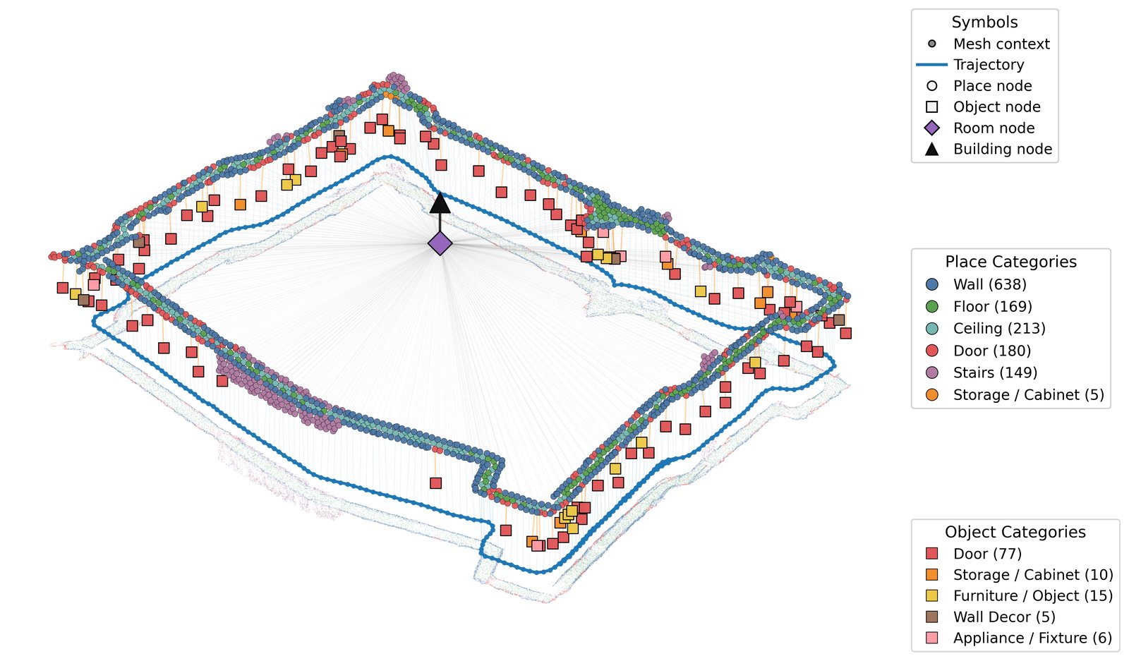
Part I. Structuring the seen
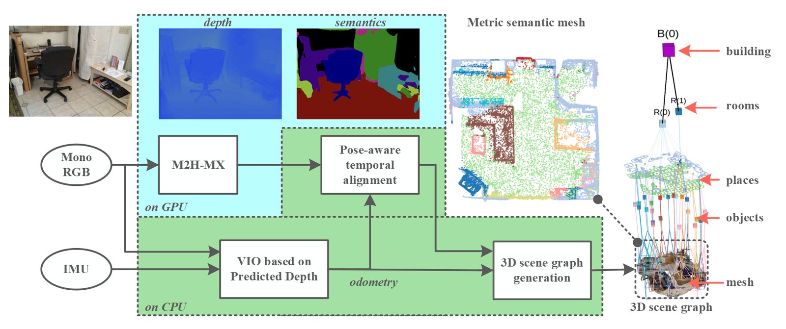
Building metric-semantic hierarchical 3D scene graphs from a single camera and an IMU, in real time.
One building, four generations
One building, four system generations, same measurement. Hardware and input resolution change across rows, so this is a system progression, not a controlled ablation.
| System | Year | Mean error | Input | Hardware |
|---|---|---|---|---|
| Mono-Hydra | 2023 | 0.19 m | 848x480 | RTX 3080 laptop |
| M2H | 2025 | 0.11 m | 224x224 | RTX 3080 laptop |
| M2H-MX-B | 2026 | 0.10 m | 640x480 | RTX 4080 Super |
| M2H-MX-L | 2026 | 0.08 m | 640x480 | RTX 4080 Super |
| M2H-MX-L, embedded | 2026 | 0.22 m | 256x192 | Jetson Orin NX 16GB |
Metric-semantic mapping systems that produce usable scene graphs have almost always assumed RGB-D or LiDAR input, because reliable geometry is the hard part and a depth sensor supplies it directly. That assumption rules out the platforms where the mapping is most useful, since payload and power are exactly what limit a small drone. Removing the depth sensor was the question, and four papers answer it in sequence.
Mono-Hydra, 2023. Proving it is possible
Learned depth and learned semantics, running as two separate networks, feed a robocentric square-root visual-inertial odometry front end, and the resulting semantic mesh drives the layered scene graph. Measured against a LiDAR backpack point cloud of the ITC building it reached 0.19 m and 0.21 m mean error on two floors, at 15 fps. Read more.
M2H, 2025. One model instead of two
Two independent networks duplicate compute and produce two representations that do not agree with each other. M2H collapses them into a single multi-task model in which depth, semantics, surface normals, and edges exchange information through window-based cross-task attention. The benchmark numbers improved, and so did the map: 0.11 m on the same building, at twice the frame rate. Read more.
M2H-MX, 2026. Testing whether the map actually cares
A better benchmark score is not the same thing as a better map, and dense prediction papers usually stop before finding out. M2H-MX is evaluated twice, once as a predictor and once as the front end inside an otherwise unchanged SLAM pipeline. Average trajectory error on selected ScanNet sequences fell from 17.59 cm to 6.91 cm, which puts a monocular system close to the RGB-D baselines in the same table. The ablation attributes most of the gain to the backbone features rather than to the new decoder blocks. Read more.
Mono-Hydra++, under review. Closing the loop backwards
Everything so far runs perception forwards into mapping. Mono-Hydra++ sends it back the other way as well: predicted sparse depth enters the estimator as metric anchor factors, semantic masks keep dynamic regions out of it, and the poses that come back out temporally align the next dense predictions. 0.08 m on the ITC second floor, 0.033 m calibrated trajectory error on 7-Scenes. Read more.
Part II. Exploring the unseen Simulation validated · Drone transfer underway
A learned agent over a persistent belief graph of places, open ends and unfinished obligations, choosing where to look next in a building it has never seen.
Trained and tested in simulation. Current drone transfer underway; earlier iterations flight-tested.
The robot enters an unmapped indoor space with one forward-facing camera and has to cover it under a time budget without collision. Motion is treated as solved: a geometric planner proposes only routes it has verified against the occupancy map the robot has built. The open problem is choice, not motion, so the learned layer decides among certified options and may abstain, but never commands motion itself. ATLAS is built in PyTorch and fully trained and tested in simulation. Current work transfers the policy to the drone, building on earlier flight-tested iterations.
Predict consequences, not appearances.
The learned component sits between two deterministic layers and has no path to the actuators except by selecting an option the planner above it has already certified as safe. It may re-order those options and it may abstain. It may not invent one. The requirements that follow come from the shape of the task rather than from the hardware:
- Options are judged against one another, so two routes leading through the same opening are not treated as genuine alternatives.
- Actions are temporally extended, because passing through a doorway is locally expensive and locally uninformative, and everything of value happens afterwards. The critic credits them by their duration.
- Unfinished work is a node type rather than a heuristic: an obligation stays in the graph until it is discharged, so regions get completed and exhausted ones get abandoned on evidence rather than on a timer.
- Every edge is keyed to a certified route and its certificate hash, so the graph cannot express a way through that has not been verified.
- The reward is registered before the experiments, so the objective cannot be tuned to the result.
- No learned component is permitted to command motion. It re-orders certified options or refuses them.
Thesis
The two parts above take their names from the thesis, Structuring the Seen, Exploring the Unseen, which is expected to be completed in 2026 at the Faculty ITC, University of Twente, supervised by George Vosselman and Francesco Nex.